
About d20
In the world of aerial surveys and mapping, the FEIMA D20 stands as a versatile and reliable multi-functional UAV. This fully automatic aerial photography system is designed to meet a wide range of surveying and mapping requirements. Let’s dive into what makes the FEIMA D20 a game-changer in this field.
The FEIMA UAV D20 can be mounted with different equipment to perform tasks in different industries. It is comptible with aerial survey module DV-CAM20, five-lens oblique camera module D-OP4000, single-lens multifunctional module D-CAM5000 and other modules as well. This drone can be used for terrain surveying, mine surveying, digital city, cadastral surveying, forestry surveying, building surveying, Smart city, disaster monitoring, power inspection, public security , pipeline inspection, water supervision, environmental monitoring, forest fire prevention, etc.
Application examples
Urban planning
It provides reliable technical means for urban planning and construction, and is widely used in urban land planning, urban land use dynamic monitoring, investigation of requisition, relocation and demolition violations, new rural planning and construction, digital city modeling and other applications. The application of UAV low-altitude remote sensing aerial survey technology can save working time, improve operation efficiency, and reduce operation costs, which is the main application trend of digital city construction.
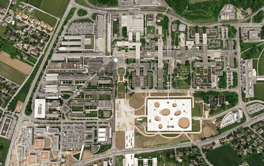
Digital city

The real scene 3D data measured and produced by oblique 3D photography technology, with its short production cycle, real and natural model, high precision, especially suitable for large-scale 3D data production, realizes the integration of oblique photography aerial data and measurable street scene data in the construction of digital city, realizes the penetration of aerial and ground data, and lays a solid foundation for the digital city to move towards a smart city.
Forestry surveys

In the post-processing of data, the independent laser return value can be divided into vegetation return value and ground return value, according to LIDAR data, analyze the coverage and coverage area of forest trees, understand the density of trees, the coverage area of older trees and the coverage area of young trees. Through LIDAR data, the forest area, the average height of trees, and the amount of wood can be estimated, which is convenient for relevant departments to carry out macro-control.
Power inspection
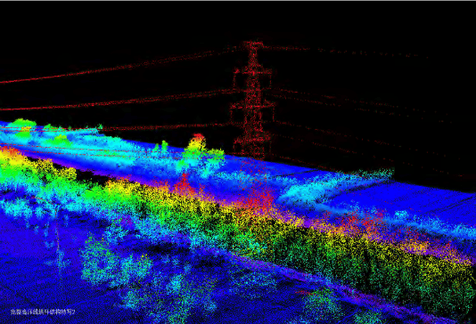
With the expansion of the power grid, line patrol work is becoming more and more important. Traditional manual inspection operations require climbing over mountains, with high operational intensity, low efficiency, high risk, and high labor costs and operating costs. UAVs can replace manual inspection to achieve efficient inspection operations, reducing labor intensity and operation risks.
Long Endurance and Heavy Load Capacity
The FEIMA D20 boasts impressive specifications. With a take-off weight of 21kg, it’s built to carry heavy loads, and its maximum endurance time extends to 80 minutes. This combination of endurance and load capacity makes it a valuable asset for various aerial missions.
Pure Electric Platform with Battery Sharing
Featuring a pure electric platform, the FEIMA D20 is not only easy to use but also highly reliable. It utilizes the same type of universal intelligent battery, enabling cross-platform exchange and sharing. This not only reduces costs but also simplifies maintenance, making the UAV a practical choice.
Universal Load Design for Enhanced Flexibility
The FEIMA D20 adopts a universal load design, allowing all loads to be interchangeable. This flexibility caters to various application scenarios and significantly increases the value of the product. Whether you’re focused on different surveying or mapping tasks, the FEIMA D20 has you covered.
High Integration, High Performance, and High Reliability
Safety and reliability are paramount for the FEIMA D20. Its core sensors employ a three-way backup system, ensuring dependable performance. Equipped with forward controllable millimeter-wave radar and a visual perception system, the FEIMA D20 can achieve functions like height measurement, obstacle avoidance, and auxiliary navigation.
Distributed Power Management System
For optimized endurance and flight stability, the FEIMA D20 utilizes an advanced distributed power management system and a battery health monitoring system. This allows for the combination of batteries according to the selected load, enhancing the UAV’s overall flight capabilities.
Support for Network RTK and PPK Calculation
The FEIMA D20 comes equipped with standard high-availability, high-reliability network RTK/PPK and its integrated solution service. This supports high-precision differential GNSS board, providing integrated solutions for RTK/PPK, high-precision POS-assisted aerial triangulation, and image-free control and mapping capabilities. It reduces field workload and ensures precise mapping results.
Comprehensive Software Solutions
The FEIMA D20 offers a one-stop software solution, supporting functions like precise 3D route planning, terrain following flight, real-time flight monitoring, GPS fusion calculation, and point cloud processing. It simplifies the entire surveying and mapping process, from route planning to data export.
Technical Parameters
| Technical Parameters | D20 |
| Material | Carbon fiber + aluminum-magnesium alloy |
| Symmetrical motor wheelbase | 1.65m |
| Body height | 0.6m |
| Drive mode | electric |
| Number of motors | 6pcs |
| Drone weight | 21kg |
| Maximum load weight | 6kg |
| Cruise speed | 18m/s |
| Battery life | 50min@6kg load, 80min@1kg load |
| Take-off and landing mode | VTOL without remote control |
| Positioning accuracy | ±1cm+1ppm (horizontal), ±2cm+ppm (vertical) |
| Climb speed | 5m/s |
| Maximum descent speed | 5m/s |
| Practical altitude ceiling | 6600m |
| Wind resistance | Level 6 |
| Control distance | 50km |
| Operating temperature | -20℃-50℃ |
| Packing shipping box | Aluminum alloy equipment box EVA lining |
| Task response time | Unfold ≤ 10min, retract ≤ 10min |
| Module load | Aerial Survey Tilt Remote Sensing Lidar Video Synthetic Aperture Radar Module |
We are proud to announce that AUAV is an authorized distributor for FEIMA drones, including the groundbreaking D20. This partnership ensures that customers can access the D20 and other FEIMA drone solutions with the assurance of quality, support, and expertise that AUAV is renowned for. With AUAV as your distributor, you can trust that you’re not only getting access to top-tier UAV technology but also a dedicated team ready to assist you in making the most of these advanced aerial solutions.
